Tel.: +86-150 7112 0854  Email: abby@tensense-geotech.com

Coal Mine Use Handheld Borehole Trajectory Instrument ——An Intelligent Solution for Underground Drilling Measurement

1. Introduction

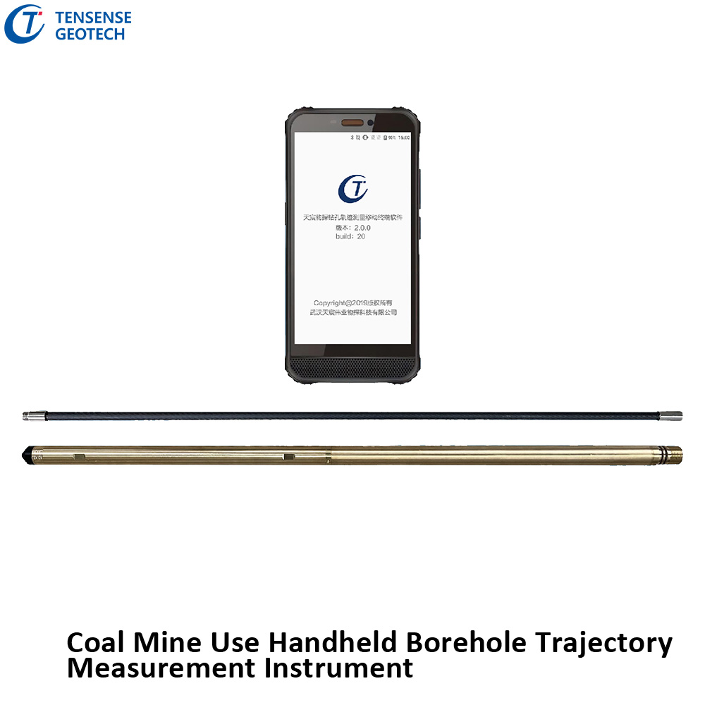
The Coal Mine Use Handheld Borehole Trajectory Instrument is a state-of-the-art device designed for precise and efficient measurement of borehole trajectories in underground mining operations. This innovative tool integrates advanced sensors, wireless communication technology, and portable hardware to provide real-time data on borehole spatial trajectories, depth, and azimuth angles. It is particularly suited for directional drilling, straight-hole drilling, and quality inspection in complex geological conditions. The primary goal of this device is to enhance the safety and efficiency of drilling operations in coal mines through accurate data collection and analysis.

Coal Mine Use Handheld Borehole Trajectory Instrument——An Intelligent Solution for Underground Drilling Measurement

2. Core Features and Advantages

2.1 Core Features

Real-Time Trajectory Measurement: Equipped with a high-precision 3D electronic compass (tilt accuracy: 0.1°, azimuth accuracy: 0.5°), the device generates real-time 3D spatial trajectories of boreholes. Automatic Depth Detection: Supports two modes—automatic measurement using the probe’s built-in sensor or synchronized counting with the drilling rig, with an accuracy of ≤1 meter. Offline Re-Measurement Compatibility: No cables are required; the probe is manually pushed into the borehole using carbon fiber rods for measurement. Wireless Data Transmission: Bluetooth 5.0 technology enables seamless communication between the probe and the explosion-proof smartphone, eliminating the need for complex wiring in underground environments.

2.2 Product Advantages

Lightweight and Efficient: The total weight is only 1.1kg (probe: 760g, smartphone: 248g, push rod: 105g), making it easy for a single operator to carry and use. Intrinsically Safe Design: Certified with Exib I Mb explosion-proof rating, suitable for gas-prone environments. Intelligent Analysis Software: Generates Word reports and exports Excel/CAD drawings with a single click, supporting unified management of borehole group data. Cloud Collaboration: Measurement data is uploaded to the cloud in real-time, facilitating remote team collaboration and historical record tracking.


3. Technical Specifications

3.1 Hardware Configuration

Component Specifications
Probe (YZG12.8-T) – Pressure resistance: ≥12MPa, continuous operation: >37 hours – Dimensions: Φ20mm×728mm, weight: 760g – Adjustable measurement interval: 1-60 seconds
Explosion-Proof Smartphone (KT653-S2) – IP65 protection, octa-core processor, 6GB RAM – Dual rear cameras (13MP night vision), supports BeiDou positioning
Carbon Fiber Push Rod – Material: Carbon fiber (tensile strength: ≥3.5GPa) – Length: 1m per rod, weight: 105g per rod

3.2 Software Features

3D Trajectory Visualization: Supports switching between horizontal projections and cross-sectional views, with automatic calculation of trajectory deviations. Borehole Group Management: Batch import of borehole data, automatic identification of coal-rock interfaces and void zones. One-Click Report Generation: Built-in templates automatically populate data, exporting reports in Word/PDF formats.

4. Application Scenarios and Operation Process

4.1 Typical Application Scenarios

Gas Drainage Boreholes: Real-time monitoring of borehole trajectories ensures accurate penetration of target coal seams. Roadway Support Boreholes: Detects borehole verticality to prevent support failures caused by deviations. Hydrogeological Exploration: Multi-hole continuous measurement analyzes formation structures, identifying aquifers and faults.

4.2 Operation Process

Device Assembly: Connect the probe to the carbon fiber push rod and pair it with the explosion-proof smartphone via Bluetooth. Parameter Configuration: Input borehole attributes (e.g., ID, designed inclination/azimuth) on the smartphone. Push and Measure: Manually push the probe to the bottom of the borehole; the system automatically records trajectory and depth data. Data Transfer: After retracting the probe, data is automatically synchronized to the smartphone, generating visual reports.

5. Safety and Certifications

Coal Mine Safety Certification: Complies with GB3836-2010 intrinsically safe standards (Exib I Mb). Environmental Adaptability: Operating temperature: -20°C to 60°C, humidity: ≤95% RH (non-condensing). Long-Term Stability: The probe’s 32GB flash memory supports storage of over 100,000 data sets.

6. Conclusion

The Coal Mine Use Handheld Borehole Trajectory Instrument addresses the inefficiencies and inaccuracies of traditional borehole measurement methods through its lightweight design, high-precision sensors, and intelligent software. Its wireless and cloud-based features represent a significant step toward digitalization and remote operation in underground mining. As 5G and AI technologies continue to evolve, this device is poised to play an even greater role in the development of smart mines.