
Tel.: +86-150 7112 0854 Email: abby@tensense-geotech.com

Tel.: +86-150 7112 0854 Email: abby@tensense-geotech.com

无线探地雷达.jpg)
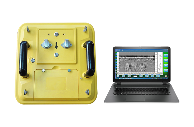
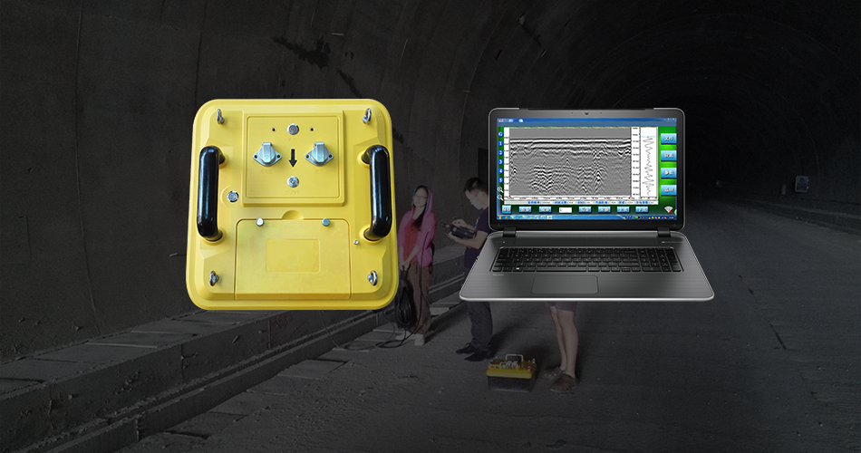
The TS-WGR1201(A) Wireless Ground Penetrating Radar is a state-of-the-art subsurface detection system that leverages an ultra-long pseudo-random coding mechanism and ultra-wideband sampling technology at its core. This advanced digital design not only encompasses all capabilities of traditional ground-penetrating radars but also introduces a suite of enhanced features, including wireless data transmission, integrated hardware and software filtering, time-variant gain control, software-based delay adjustments, and customizable sampling parameters. Adhering to the standard IEEE 802.11 communication protocol, it facilitates automatic parameter configuration for optimized performance.
Pioneering in its class, Tensense’s radar system stands as the industry’s first to incorporate wireless transmission capabilities, enabling seamless integration with a wide array of WLAN-enabled devices such as laptops and tablets for real-time display and data storage. With a high-capacity battery that supports continuous operation for over 14 hours, this radar system is designed to deliver reliable, long-lasting service in various challenging environments.
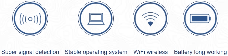
Advanced Ultra-Wideband Technology:
Utilizes leading-edge ultra-long pseudo-random coding and ultra-wideband sampling techniques, ensuring exceptional signal detection and unrivaled subsurface imaging precision for diverse applications.
Wireless Connectivity with IEEE 802.11 Standard
As the industry’s first radar system to incorporate wireless transmission capabilities, it offers agile and efficient data management through any WLAN-enabled device, such as laptops and tablets, for enhanced field mobility and user convenience.
Extended Operation with High-Capacity Battery
Engineered for longevity, the TS-WGR1201(A) features a robust high-capacity battery, supporting over 14 hours of uninterrupted operation, ensuring dependable performance and peak productivity on every project site, no matter the duration or distance from power sources.
Main Applications:
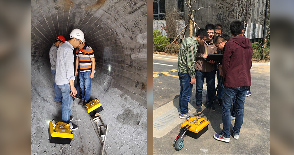
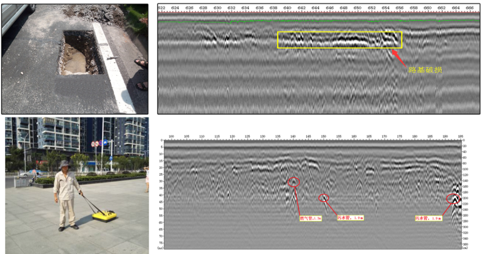
Infrastructure Inspection: Assessing the integrity of roads, bridges, and tunnels by detecting delaminations, voids, and reinforcement corrosion.
Utility Locating: Identifying and mapping underground utilities such as pipes, cables, and fiber optics to prevent damage during construction.
Geotechnical Surveys: Evaluating soil and rock conditions for construction projects, including the detection of potential geological hazards.
Environmental Monitoring: Investigating subsurface contamination, including the location of pollutants and the monitoring of waste disposal sites.
Archaeological Exploration: Uncovering buried archaeological sites, such as ancient structures and historical artifacts.
Agricultural Analysis: Examining soil composition and moisture content to optimize irrigation and farming practices.
Mining Operations: Detecting mineral deposits and voids in the earth, aiding in the planning and safety of mining activities.
Disaster Response: Locating survivors and assessing structural damage following natural disasters such as earthquakes and landslides.
Coastal and Marine Studies: Mapping the seafloor and investigating underwater structures in freshwater environments.
Security and Surveillance: Detecting buried objects and potential threats in security-sensitive areas.
Features:
Customizable Frequency Range: Adapts to various underground materials with a flexible frequency spectrum from 16MHz to 2.6GHz.
Wireless Data Transfer: Streamlines operations with the ability to transmit data wirelessly to a range of devices.
Advanced Signal Processing: Enhances data quality through hardware and software filters, time-varied gain, and software delay adjustments.
Intuitive Software Interface: Simplifies user interaction with straightforward controls and data interpretation tools.
High-Resolution Imaging: Delivers clear and detailed underground images for accurate analysis.
Adjustable Sampling Rates: Offers a range of 50k to 285kHz for tailored data collection based on the environment.
Durable Battery Life: Ensures long-term operation with a high-capacity battery supporting over 14 hours in the field.
Robust Operating System: Provides a stable platform for reliable performance in diverse conditions.
Ease of Deployment: Designed for quick setup and ease of use, reducing the time from unpacking to data collection.
Versatile Application Suitability: Ideal for a wide array of professional uses, from geotechnical surveys to utility mapping and beyond.
Technical Introduction:
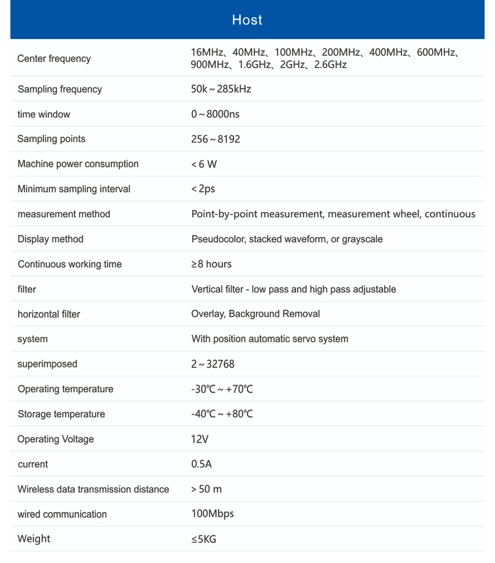
Center Frequencies: Available options ranging from 16MHz to 2.6GHz to accommodate various penetration depths and resolution requirements.
Horizontal Filter: Features include stacking and background removal for enhanced signal clarity and noise reduction.
Sampling Frequency: Adjustable from 50kHz to 285kHz, allowing for optimized data acquisition for different subsurface materials and conditions.
System Features: Includes an automatic position servo system for precise signal reception.
Time Window Range: 0 to 8000 nanoseconds (ns) for versatile data capture.
Overlap: 2 to 32768 scans, providing detailed subsurface profiling.
Sample Points: 256 to 8192 sample points per scan, offering high-density data for intricate subsurface mapping.
Operating Temperature: Capable of functioning effectively in a wide temperature range from -30°C to +70°C.
Total Power Consumption: Less than 6 watts (W) for energy efficiency during operation.
Storage Temperature: Designed to withstand temperatures from -40°C to +80°C, ensuring reliability in extreme conditions.
Minimum Sampling Interval: Less than 2 picoseconds (ps) for high-resolution time-domain analysis.
Operating Voltage: 12V for consistent power supply.
Measurement Modes: Offers point-by-point measurement, measurement wheel, and continuous measurement for flexibility in fieldwork.
Display Options: Pseudocolor images, stacked wave forms, or grayscale images for various data visualization preferences.
Wireless Data Transmission Range: Exceeds 50 meters for reliable wireless operation.
Continuous Operation Time: Ensures a minimum of 14 hours of uninterrupted use on a single battery charge.
Wired Communication: Supports Ethernet connectivity at 100Mbps for data transfer and networking.
Filter Options: Vertical filters with adjustable low-pass and high-pass settings for targeted signal analysis.
Weight: Less than 5 kilograms (kg) for portability and ease of transport.
Uploading…
 Wide Application
Highly adaptable for a wide range of geotechnical applications, providing consistent and reliable results in diverse subsurface environments.
 Precise sediment readings with low error margins
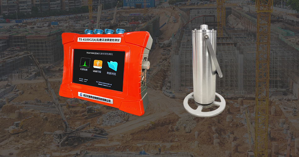
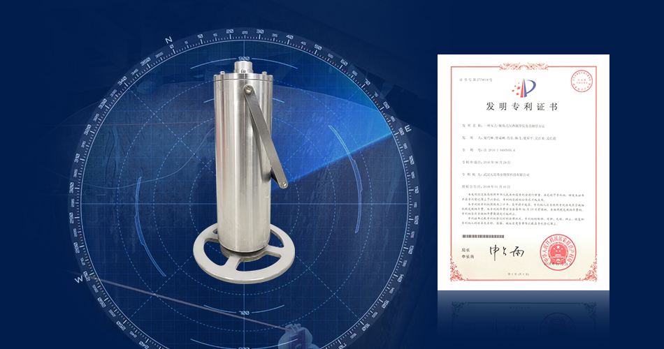
The probe is small in diameter and can reach the hard rock stratum at the bottom of the pile.The probe has a built-in inclination sensor to ensure that the probe is upright.
 Comprehensive and easily interpretable data outcomes
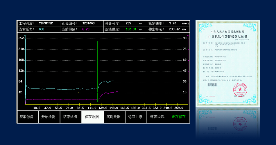
real-time graphical representation of depth pressure curves and inclination metrics, facilitating straightforward identification of sediment thickness.
Main Applications:
Features:
Technical Introduction:
Comprehensive Application Scope: The TS-K100CZ(A) is versatile, suitable for sediment thickness detection across various hole and trench configurations, unaffected by the subterranean medium’s characteristics.
Optimized Measurement Precision: With a minimal influence from external factors, the device boasts high accuracy in measurement. The slender probe design facilitates reaching the bedrock at the hole’s base, while the probe’s tray ensures stable contact with the sediment surface. The integrated angle sensor maintains the probe’s vertical alignment, resulting in sediment thickness measurements with an accuracy of up to 0.1mm.
Real-Time Data Visualization: The TS-K100CZ(A) provides an intuitive display of the pressure-tilt angle curve and the probe’s extension length, enabling immediate and precise determination of sediment depth.

Uploading…